Mystics and Magicians Cricket Club - Directions to Grounds
M.M.C.C. - They have Pro's, we have Poetry
postcode: PL26 6HN
The cricket ground is opposite Gorran School and about a mile away from Boswinger Youth Hostel along quiet country roads.
The nearest pub is The Barley Sheaf) in Gorran Churchtown. From the car park there, turn left past the front of the pub and past Gorran Store. After a few hundred yards, you'll drop down to a junction. Follow the right turn to Boswinger, Penare, Caerhays and Veryan. The speed limit drops to 20mph and the cricket ground soon opens up on your right.
Back to Fixtures Page
postcode: PL30 3AG
 From Bodmin take the A389 towards Wadebridge. You'll pass the Borough Arms pub on your left as you go down hill to the River Camel. Carry on over the old railway line and across the bridge, up the hill and follow the road passing the turning for Camelford (B3266) on your right. Keep heading towards Wadebridge and pass through a small place called Washaway.
Pass a right turn to St Mabyn (three miles) and Camelford (ten and a half miles). About 100 yards later, fork right past Trehellas Hotel and Restaurant. It's also signposted to Croanford (one mile).
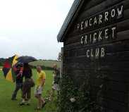
Stuart Ellis says that you'll soon start to think that you're lost, but he says that you shouldn't worry. Follow this narrow lane through the woods and Pencarrow Cricket Club should appear on your left just before the crossroads (you'll see two huge oak trees on your right). Be careful when turning in as the gateway is narrow, and newcomers tend to scrape their cars.
From the Wadebridge side, you should head south past The Slades House Country Inn in Sladebrige. After about a mile and a half, take the second left after big right-hand bend, signposted to Croanford (half a mile) and St Mabyn (two miles). Drive half a mile up the road to a crossroads. Turn right, ignore the entrance to Pencarrow House on the left and obey the signs that point right into Pencarrow Cricket Club. Don't park where Chris and Kate parked in 2009.
Click the picture above for a link to a Google Map centred on the ground (check the satellite view to see exactly where the ground is).
For pre-match drinkers, the best bet seems to be the Saint Mabyn Inn (PL30 3BA), which is in the centre of Saint Mabyn - follow signs from the A389. To get to the ground from there, follow the Wadebridge Road from the centre of the village (to Wadebridge and Pencarrow on the signpost next to the war memorial). Pass the post office, the church and the school. Pass the village hall, an unpromising-looking crossroads and Mabena Close on the right, and you're out of Saint Mabyn.
After another 400 yards, you get to a crossroads - though you should just follow the road around to the left, ignoring the tiny roads ahead and to the right. 500 yards further along, as the road bends right towards Pencarrow, you need to keep straight on, following the sign to Bodmin. Pass a farm track on the left after 300 yards and the road starts to wiggle as it heads down towards a stream and then back up again. The road straightens and, after 300 yards, leads to a crossroads. Follow the straight on (towards Washaway, 1 mile, and Bodmin, 4 miles) and the entrance to the ground is on your right after 50 yards.
Back to Fixtures Page
postcode: PL22 0RF
 Head east (back towards Devon) on the A390 out of Lostwithiel. On the right about a mile out of town (a couple of hundred yards past Saint Winnow School and just about the place where the 40-mph zone ends) is Downend Garage. Turn right there (signposted to Lerryn, 3 miles, and Couch's Mill, 2 miles). Follow the road around to the left at Duchy Timber and less than a mile's drive will bring you to a T-junction. Take the left towards Couch's Mill and Liskeard. After about half a mile, bear right (towards Couch's Mill and Lanreath) at a grassy triangle of a junction. In a bit more than half a mile there's a left turn with a heavy-duty white picket gate across it. Open the gate and go through it, remembering to shut it behind you. The sightscreens should be visible pretty soon as you drive along the road, keeping right where you have a choice.
The pitch is very clear on the Google Map satellite image.
Back to Fixtures Page
postcode: TR2 5UW
From the New Inn in the middle of Veryan turn left uphill along Green Lane towards Pendower, Portscatho and St Mawes. Turn right after about 100 yards (just before Treverbyn House Bed and Breakfast) towards Portscatho and St Mawes. Leave the 20mph zone (the speed limit becomes 30mph). Take the left past the netting that appears over the left-hand hedge. The big green sign says Veryan Sports and Social Club.
If you get to the nathional-speed-limit sign, you've gone too far.
Back to Fixtures Page
postcode: PL14 6NN
Saint Neot is about two miles North of the midpoint on the A38 between Bodmin and Liskeard. Your best bet, I reckon, is to head along the A38 and keep an eye out for signposts.
Once you're in the village, you'll see a pub called The London Inn. an alternative option for lunch is the Halfway House, which should be open. It's on the A38, on the left, by the first turn to Saint Neot.
Past the London Inn, there is a church on your left. Just notice it, don't deviate from your course. Then there is a fork in the road. Bear left up the hill (blue sign to "Saint Neot Taverners C.C."). Turn right at the first crossroads (another blue sign to "Saint Neot Taverners C.C."), and drive for about a third of a mile. The entrance to the ground is a gap in the hedge on the left after some farm buildings. There is a small sign in the hedge.
Click the picture above for a link to a Google Map centred on the ground (check the satellite view to see exactly where the ground is).
Back to Fixtures Page
postcode: PL26 7PX
The A3058 road between Newquay and Saint Austell goes through the southern end of Saint Stephen. Heading east along that road into the village, you'll pass a Kia garage on the right. Keep going along Terras Road a few hundred yards and then turn left into Fore Street (sign to Free Parking, 330 yds). Pass a launderette, a takeaway, a hairdresser and a Co-op and keep on for about another 200 yards and the cricket ground is on the right, just past the Community Centre.
Back to Fixtures Page
postcode: TQ13 9TJ
We'll be playing at Lustleigh cricket ground and drinking at The Cleave. In fact, if you can find the pub, you can find the ground. Which is as it should be.
The A382 runs between Bovey (pronounced Buvvy) Tracey and Moretonhampstead, and Lustleigh is just off that, roughly halfway between the two towns. From the north, take the right turn (Knowle Road) next to a thatched cottage. It's signed to Lustleigh and has a "The Cleave" sign as well. There is an earlier right turn (Caseley), but that has a sign saying that it's unsuitable for wide vehicles. I'd stick with Knowle Road.
It bends sharply to the left and then to the right before coming to a sort of crossroads. Follow the road around to the right and it becomes Brookfield. The field on your left used to be full of Erratic campers most summers, and the cricket ground is just past that. Go over a hump-backed bridge and then follow the road around to the left past Beechnut Lodge. The road narrows as it nears the village centre.
The one-way system takes you around to the left of the church and the pub is on the left. The ground is at the bottom of a narrow, upromising-looking lane next to (on the right of) the pub.
Back to Fixtures Page
postcode: EX5 3LE
 We will probably meet at The Red Lion in Broadclyst, which is on the left as you head north along the B3181.
From the village of Broadclyst, head north on the B3181 for a couple of miles and turn left before you get to Budlake. Go over the M5 and then take the left into Killerton House. There are brown National Trust signs to help you find the house.
Once you're on the road to the house, keep straight on past the right turn to the National Trust car park). There is a bar in the pavilion.
Back to Fixtures Page
Back to Mystics Home Page
Index Page